 Weather
Temperature: 86°F
Conditions: HHH
Wind: SE 7 mph
Ride Info
Altimeter Trip: 1,470 ft
Altimeter Odometer: 69,190 ft
Maximum Speed: 42.5 mph
Average Speed: 18.8 mph
Distance Trip: 87.9 miles
Distance Odometer: 2,710.0 miles
Elapsed Time: 4 hr 29 min 28 sec
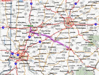
Most every evening, Coach reviews the next day’s route, describes some items of interest, and will hand out photo copies of maps to everyone. During today’s ride, the map came in VERY handy. More on that later. Vandalia is on the outskirts of Dayton, which of course if the home of Wright Patterson AFB. Traffic was pretty heavy heading out of the area. Not that we saw much, but it seemed to be a pretty big facility. I’ve noticed that the further east we travel, the more the roads and terrain remind my like home. Today’s ride was a smorgasbord of rolling hills, flat terrain, and windy roads.
It wasn’t too long into our ride before we felt hungry again so we stopped at a diner for some more breakfast. The food was really good, but something must have disagreed with my stomach because it wasn’t much longer before I had to take a major dump. So Jim and I stopped for a potty break at a McDonald’s in Washington Courthouse. After I did my business (and felt MUCH better by the way), I reached for some toilet paper, and there was NO TOILET PAPER!!! I certainly couldn’t just leave without wiping. I sneaked out of the stall to see if there were any paper towels. No luck! They had electric hand dryers. Desperate times call for desperate measures. So I took out my map (after all, Jim still had his), crumpled it up, and used my map to wipe my ass. For some reason, I felt the overwhelming urge to tell Jim about this when I met him outside. He cracked up laughing.
Most evenings are the same no matter where we stay so, for most of these journal entries, I feel there’s no sense repeating myself about what I did every night. But since I haven’t mentioned it in a while… Dinner was usually around 6:00. This gave enough time for all the stragglers to mosey on in, but it also gave time for our kitchen help to drive to the final destination, buy that day’s meal at the local grocery store, and prepare the meal in the mobile kitchen. I was almost always at the front of the chow line. Usually, Coach would lead the group in a prayer before dinner was served. That was something that made me a little uncomfortable but I tolerated. After dinner, I would call my parents and then write my daily letter to my girlfriend, Laura. Of course, people would hang out and BS with each other sharing stories of the day’s adventure.
Tomorrow’s ride would take us over the Ohio River and into yet another state – West Virginia. I was really psyched for West Virginia as I was eager to tackle some steep hills. To be honest, I was disappointed with the difficulty level of much of the Rockies. Besides that one day in South Dakota, I didn’t really bust a lung on any of the climbs.
I'm Home!
10 years ago


5 comments:
It wasn't difficult in the rockies? Are you serious?? I always imagined there would be no biking possible through much of them. Maybe they took you the least dangerous way through them? Someday I want to see the Rockies! :)
Oh and that map came in handy. Did you flush it? And did it go down? lol
I'm sure there are plenty of long, steep hills in the Rockies. And the ones we went on were still challenging. But think about it. The roads in the Rockies can be 10 miles long. The roads are purposely longer and at a gentler grade so it's safer for cars and trucks. The hills in the east are typically shorter (3 miles) and steeper.
I don't remember if I tried flushing the map. Fortunately, one sheet was enough to do the job!
Yeah that makes sense. I've heard they don't have guardrails either and there are steep drop-offs. Mt. Washington scared me so bad, wow! Narrow, steep road with no guardrails. Did you say you rode a bike up there before? And a couple weeks ago, we drove up Whiteface which was a piece of cake, very safe.
Hey maybe you can put in a tip for recylcing maps to AAA. :)
I rode up Mt Greylock which is the highest point in Massachusetts. That's about 7 miles long and VERY steep. I think that Mt Washington is a couple miles longer even. The weather up there is unpredictable too (as you probabl know). I haven't ridden up Mt Washington. The road up Whiteface is closed to bikes about halfway up. I rode my bike up to that point. Vickerman Hill heading south out of Mohawk is another great hill. That has a runaway truck emergency stop thingy at the end.
Yeah I think Mt. Washington was like 12 miles to the top. And crazy weather up there. Never been to Mass., someday will go there! I'm always more scared going up than coming down. Not sure why. I'm scared of heights but it's thrilling to be up there, once you get there. :)
I'd never ride a up or down a bike on one of those though. You've got guts!
Post a Comment